The tropical depression over the South China Sea strengthened into this year's 16th typhoon, 'Taba', at 8:00 pm that day, and is bringing wind and rain as it heads towards the southeast coast of China.
According to China News Service, as of 8:00 pm on Saturday (September 6), the center of 'Taba' was located at latitude 18.3°N, longitude 115.7°E, approximately 610 kilometers southeast of Dianbai District, Maoming City, Guangdong Province, at sea. The maximum wind speed near the center was force 8 (18 meters/second).
'Taba' is expected to move in a northwesterly direction at a speed of 10 to 15 kilometers per hour, gradually intensifying and heading towards the central and western coast of Guangdong.
The China National Meteorological Center forecasts that 'Taba' will make landfall along the coast from Zhuhai to Zhanjiang in Guangdong between the early morning and noon of the 8th (as a severe tropical storm or typhoon), and will weaken gradually after making landfall.
Under its influence, from the night of the 6th to the 9th, most areas of the South China Sea, the Qiongzhou Strait, Beibu Gulf, and the coastal areas of South China will experience strong winds, ranging from force 6 to 8. Some central and northern parts of the South China Sea will see winds of force 9 to 10; sea areas or regions near the typhoon center could see winds of force 11 to 12, with gusts reaching force 13 to 14.
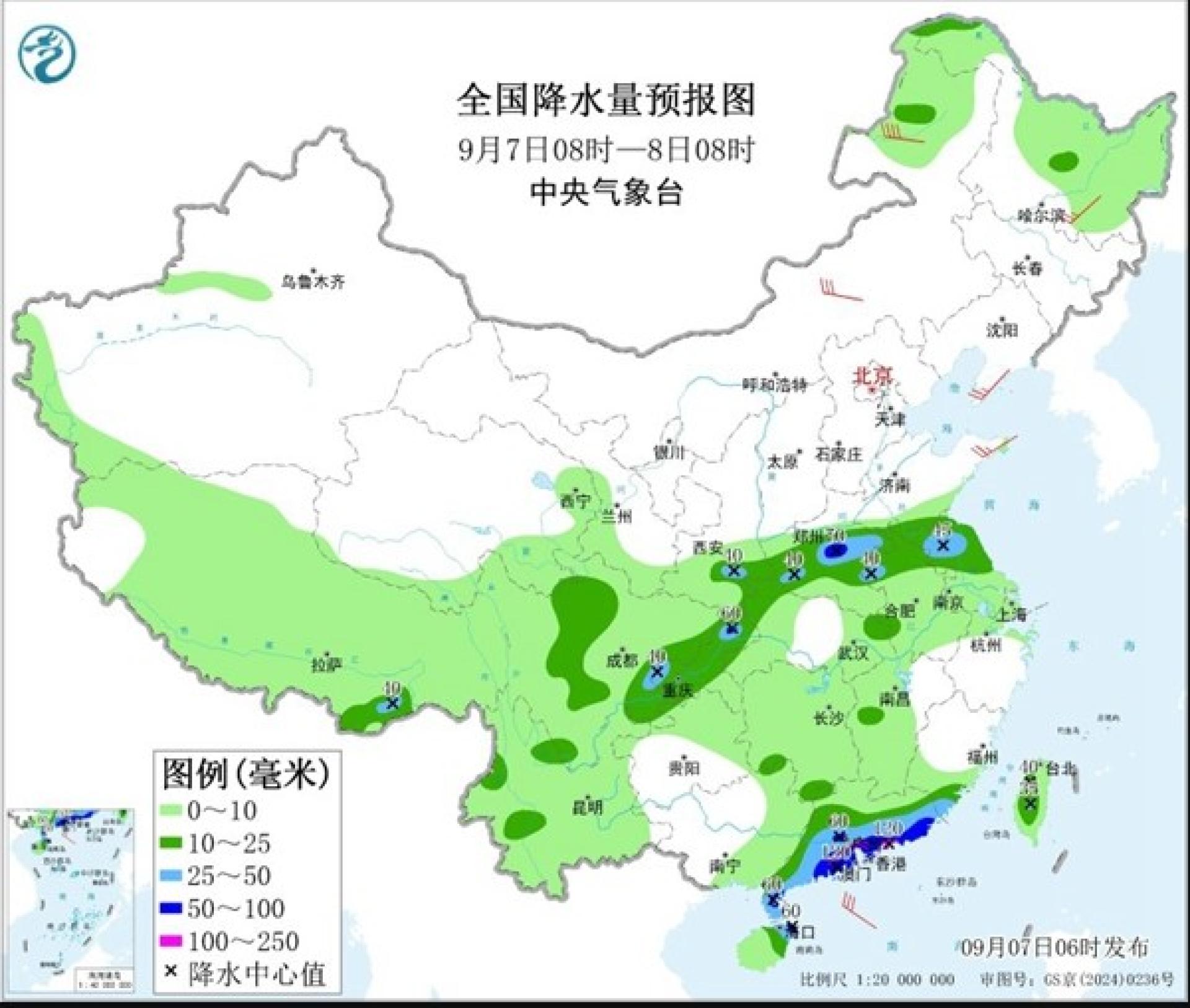
From the 7th to the 10th, heavy to torrential rain is forecast for southern and central South China and most of Yunnan province. Southern Guangdong, northern Hainan Island, southern Guangxi, southern Yunnan, and other regions will see very heavy rain, with local extreme downpours in southwestern Guangdong and southeastern Guangxi. Total rainfall in some of these areas will be 80mm to 180mm, with local amounts reaching 250mm to 400mm.
Additionally, due to the combined effects of the westerly system and remote moisture transport from the typhoon, from the 7th to the 10th, western and northern Sichuan Basin, as well as areas stretching to southern Jianghuai and Huanghuai, will experience heavy to torrential rain. Northeastern Sichuan, southern Shaanxi, northern Chongqing, as well as northern Jiangsu and Anhui, will see localized extreme downpours, with cumulative rainfall reaching 150mm to 270mm.
According to the "National Flood and Drought Emergency Plan" and related regulations, the China National Flood Control and Drought Relief Headquarters launched a level IV emergency response for flood and typhoon control for Guangdong and Hainan at 6:00 pm on the 6th, and dispatched a working group to Guangdong to assist and guide flood and typhoon prevention work.
According to China News Service, as of 8:00 pm on Saturday (September 6), the center of 'Taba' was located at latitude 18.3°N, longitude 115.7°E, approximately 610 kilometers southeast of Dianbai District, Maoming City, Guangdong Province, at sea. The maximum wind speed near the center was force 8 (18 meters/second).
'Taba' is expected to move in a northwesterly direction at a speed of 10 to 15 kilometers per hour, gradually intensifying and heading towards the central and western coast of Guangdong.
The China National Meteorological Center forecasts that 'Taba' will make landfall along the coast from Zhuhai to Zhanjiang in Guangdong between the early morning and noon of the 8th (as a severe tropical storm or typhoon), and will weaken gradually after making landfall.
Under its influence, from the night of the 6th to the 9th, most areas of the South China Sea, the Qiongzhou Strait, Beibu Gulf, and the coastal areas of South China will experience strong winds, ranging from force 6 to 8. Some central and northern parts of the South China Sea will see winds of force 9 to 10; sea areas or regions near the typhoon center could see winds of force 11 to 12, with gusts reaching force 13 to 14.
From the 7th to the 10th, heavy to torrential rain is forecast for southern and central South China and most of Yunnan province. Southern Guangdong, northern Hainan Island, southern Guangxi, southern Yunnan, and other regions will see very heavy rain, with local extreme downpours in southwestern Guangdong and southeastern Guangxi. Total rainfall in some of these areas will be 80mm to 180mm, with local amounts reaching 250mm to 400mm.
Additionally, due to the combined effects of the westerly system and remote moisture transport from the typhoon, from the 7th to the 10th, western and northern Sichuan Basin, as well as areas stretching to southern Jianghuai and Huanghuai, will experience heavy to torrential rain. Northeastern Sichuan, southern Shaanxi, northern Chongqing, as well as northern Jiangsu and Anhui, will see localized extreme downpours, with cumulative rainfall reaching 150mm to 270mm.
According to the "National Flood and Drought Emergency Plan" and related regulations, the China National Flood Control and Drought Relief Headquarters launched a level IV emergency response for flood and typhoon control for Guangdong and Hainan at 6:00 pm on the 6th, and dispatched a working group to Guangdong to assist and guide flood and typhoon prevention work.